Finding Utah Butterflies-->Utah's Dixie
Utah's physiogeographic region known as "Utah's Dixie" is located in the southwest corner of the state in Washington County. It represents one of the most picturesque biodiverse regions of Utah and one of the most scenic areas in the world. Sections of this region also known as "Utah's Color Country" display abrupt topographical changes ranging from volcanic remnants and mountains to Navajo sandstone hills and buttes; from a vast pinyon juniper mountainous terrain in the Pine Valley Mountains to the Joshua Tree Creosote covered Beaver Dam Mountains. In the words of Schmerker, "Utah's Dixie is where the Basin and Range province, the Colorado Plateau and the Mojave Desert converge into a surreal pile of rocks, flora and fauna..."
The
Utah Mojave represents the northeastern limits of the Mojave Desert and is
situated in the extreme southwest corner of Washington County. At a
statewide elevational low of 2,200 feet, it includes the Mojave desert floor,
the Beaver Dam Wash, the Beaver Dam Slope, and even portions of the Beaver Dam
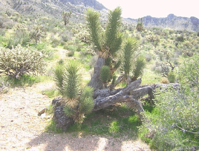
Mountains where Yucca brevifolia (Joshua trees) make an attempt to climb
the mountains. However, as witnessed by those who have driven old US 91,
Joshua trees haven't quite made it over the summit of Utah Hill.
Another plant that seems Utah Mojave specific is Thamnosma montana (turpentine broom); the larval hostplant of Papilio coloro (the desert swallowtail). Other butterflies that one might find in the Utah Mojave are Thessalia leanira alma (leanira checkerspot), Apodemia mormo mormo (mormon metalmark), Callophrys comstocki (desert green hairstreak), Heliopetes ericetorum (northern white skipper), and, in some years, Libytheana carinenta larvata (american snout).
The Virgin River Basin represents the riparian section of the St. George basin and includes the Santa Clara and Virgin Rivers. The plant community found here include Larrea tridenta (creosote bush), Atriplex lentiformis (big saltbush), Phragmites australis (common reed), Baccharis glutinosa (false seep willow), Salix exigua (sandbar willow), Populus fremontii (cottonwood), and, unfortunately, Tamerisk ramosissima (salt cedar). Some of the butterflies that you would find here are Danaus gilippus thersippus (queen), Precis coenia (buckeye), Ochlodes yuma yuma (yuma skipper), and Limenitis archippus obsoleta (arizona viceroy).
The Dixie Corridor, on the other hand, represents the rest of the St. George basin including low elevation lava hills and ridges, buttes, red navajo sandstone hills; as well as the Yucca utahensis, Larrea, and Rumex covered sand dunes found in the vicinity of Warner Valley. Some of the butterflies and skippers that you would find in this subsection would include Chlosyne lacinia (bordered patch), Anthocharis cethura pima (desert orangetip), Euchloe hyantis lotta (desert marble), Euphydryas anicia hermosa (variable checkerspot), Chlosyne neumoegeni neumoegeni (desert checkerspot), Papilio indra calcicola (cliff swallowtail), Apodemia palmeri (palmer's metalmark), Pyrgus scriptura (small checkered skipper), and Megathymus yuccae coloradensis (yucca giant skipper).
The Montane region of Utah's Dixie is represented mainly by the Pine Valley Mountains--the highest point reaching 10,365 feet--in the northcentral portion of Washington County. One of the more picturesque canyons in Utah's Dixie that demonstrates a subtle transition from Dixie Corridor to Montane is Leeds Creek or Leeds Canyon.
The mouth of Leeds Canyon (3900') contains navajo sandstone ridges with a desert community of common trees and shrubs such as Larrea tridenta (creosote bush), Juniperus osteosperma (utah juniper), Quercus turbinella (permanent oak), Populus fremontii (cottonwood), and Prunus fasciculata (desert almond). Some of the butterflies that you might find at the lower area of Leeds Creek include Callophrys siva siva (juniper hairstreak), Nymphalis antiopa (mourning cloak), Anthocharis cethura pima (desert orangetip), Anthocharis sara thoosa (southwestern orangetip), Adelpha eulalia (arizona sister), Brephidium exilis (pygmy blue), Euphydryas anicia hermosa (anicia checkerspot), Cyllopsis pertepida dorothea (canyonlands satyr), and Erynnis meridianus (meridian duskywing).
As you proceed up the canyon heading east towards Oak Grove Campground; approaching the Pine Valley Mountains, the desert community transitions from creosote shadscale scrub to pinyon juniper. At the same time, as you proceed up the canyon, Quercus turbinella is replaced by Quercus gambellii; Penstemon palmeri is replaced by Penstemon eatonii; and Lomatium parryi (parry lomatium) is replaced by a small population of Lomatium scabrum tripinnatum (cliff lomatium).
One of the special species of butterflies that is found on occasion in the higher portion of Leeds Canyon at Oak Grove Campground is Papilio bairdi (baird's swallowtail).
Another locale in the Pine Valley Mountains is Pine Valley Campground itself. Although Pine Valley Campground is only roughly four aerial miles from Oak Grove Campground, it would require a 63 mile drive to access one from the other as the terrain separating the two campgrounds is rugged wilderness. Therefore, Pine Valley Campground is only accessible from the northwest from Utah Hwy 18; and then southeast from Central.
At an elevation of 7,000 feet, the ponderosa pine/aspen community of Pine Valley Campground is picturesque and offers a unique mix of butterflies including Adelpha eulalia (arizona sister), Limenitis weidemeyeri weidemeyeri (weidemeyer's admiral), Papilio bairdi (baird's swallowtail), Papilio rutulus (western tiger swallowtail), Papilio multicaudatus multicaudatus (two-tailed swallowtail), Zerene cesonia (southern dogface), Ochlodes sylvanoides omnigena (woodland skipper), Speyeria nokomis apacheana (nokomis fritillary), and Speyeria hesperis chitone (northwestern fritillary).
The Plateau region of Utah's Dixie includes the navajo sandstone, chinlea, and other rock formation knolls, buttes, and mesas located in the south southeastern portion of Washington County including Warner Ridge, Sand Mountain, Mollies Nipple, Vermillion Cliffs and Hurricane Cliffs transitioning into Zion National Park.
Some of the butterflies that you would find in this region include Precis coenia (buckeye), Apodemia mormo mormo (mormon metalmark), Polygonia satyrus (satyr comma) Brephidium exilis (pygmy blue), and Megathymus yuccae coloradensis (yucca giant skipper). Please see our Utah Lepidopterists' Society page to get a more complete checklist of butterflies from Utah's Dixie.
_________________________________________________________________________________
